Of all my years of climbing, I never imagined that I’d actually be able to reach the Philippines’ highest summit. It had always been just a nice idea.
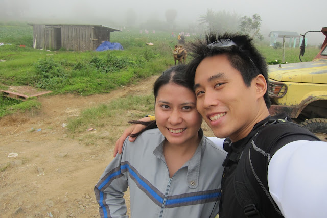
I have been trying to book this trip for two years but because of other priorities, I had to cancel this trip…TWICE! In November of 2011 when I booked the trip to Davao, I did not count on it too much because at the back of my mind, something might come up again…but…BUT…In February 5, 2012 at 5:00am, I found myself boarding a plane to Davao!
Touchdown…
We landed early in the morning. The first thing I noticed about the airport was that it was very clean and fully functional…a good start to our 2-week trip. After leaving our bags at the hotel and getting additional trail food, we rode the van for 30-minutes to meet up with our guides. We then transferred to a 4x4 pickup truck before heading to Camp Sabros. On the way to the camp, we stopped by the Baragay Kapatagan outpost to pay for our climbing fees. Currently, the rate is Php720.00 per person.


The road to Camp Sabros is very rough and one could only get there via 4x4 vehicle or habal habal or a horse. The place is surrounded with pine trees violently swaying because of the strong wind and breeze is cold (similar to the temperature in Baguio on a cold day).
We only stayed for about 20 minutes to try their zipline.


My verdict…Value for your money. They offer several stages of zipline that vary in distance and form. Unlike some of the ones that I have tried before, the distance of each stage is enough to get your blood pumping and leave you wanting more. The line is positioned in a way that your speed gets faster and faster as you reach the end of the line. It will give you quite a good rush as you enjoy the view!
Mt. Apo
From Camp Sabros, we made a very rough and shaky hour and a half ride via 4x4 to Purok Mainit. By then it was already 11:30 in the morning so we stopped to have our packed chicken adobo and rice lunch and to make sure that we have everything that we needed.
Because of my crazy busy schedule prior to this trip, I did not have any pre-climb training at all. As we were gearing up, all I could think of was AM I SURE I WANT TO DO THIS?...AM I ABSOLUTELY SURE I WANT TO DO THIS?


Day 1 - The Journey Begins…
Mount Apo is located in Mindanao, Philippines. It is a potentially active stratovolcano at 2,954 metres (9,692 ft), the highest in the country. It towers over several regions in Mindanao - Davao City and Davao del Sur province in Region XI and Cotabato province in Region XII. The peak overlooks Davao City 40 kilometres (25 mi) to the northeast, Digos City 25 kilometres (16 mi) to the southeast, and Kidapawan City 20 kilometres (12 mi) to the west.
The word Apo in the vernacular has several meanings: 1.) Ancestor/grandfather; 2.) Master 3.) Autocrat (a ruler who possesses absolute and unrestricted authority). The name fits perfectly because its magnitude, the height, the challenges, the danger, the burning heat, the bitter cold, the spectacular view and the flora & fauna that one experiences and encounters when climbing the mountain demand no less than absolute respect.
Since the Mt. Apo mountain range towers over several regions of Mindanao, there are many trails to the Summit. Our game plan was to enter through the Kapatagan trail in Davao del Sur and exit to The Mainit trail in Agco, Kidapawan.
We started out trek towards the Kapatagan trail at 12:00 noon. At this time of the day, it was already very cold and foggy. As I walked, I passed by several mountain fields of potato, carrots, cabbage and many other vegetable varieties. Through the thick fog, I constantly saw ghostly images of trees seemingly getting bigger and bigger and then smaller and smaller, as if I was hallucinating. There were also ghostly sounds of farmers talking, kids giggling and playing and dogs barking coming from nowhere! I would make stops to admire and soak up everything around me while being very careful not to keep too far a distance from my guide in front of me because I could have easily gotten lost out there. The visibility was only about a meter or two.


After the fields was a jungle with very thick vegetation, a lot of obstacles, muddy trail and a lot of fallen trees. We made several stops to catch our breath and just before our last stop, it rained on us! We fashioned improvised rain coats from big trash bags. It helped a bit to keep us dry but by the time I reached Camp Baroreng (our home for our first night), I was already shivering nonstop! It was only 4:00 in the afternoon but the temperature was 14°C.


Camp Baroreng is a few hundred meters away from a clean water source. When I say clean, I mean potable and better tasting that the bottled water that we drink in Manila. It is a relatively small camp with no view and surrounded by tall trees, ferns and different plants. Good thing we were the only ones there.
We had coffee to keep us warm, cleaned up and changed into dry clothes. We had dinner at around 7:00 in the evening. Our meal was a comforting and delicious stew of chicken, carrots, bell pepper, greens, broccoli, sayote, potato in clean broth with very hot rice.
By 8:00pm, we were ready to sleep. Though we had layers and layers of clothes, gloves, socks, bonnets, scarves, malongs and sleeping bags, I still woke up shaking many times at night until I managed to get back to sleep. It rained until the just before sunrise.
Day 2 – Reach the heavens…
We managed to get out of our tents at 7:00am. Even way past sunrise, it was still so cold that my hands were numb and could hardly feel a thing while eating breakfast. Our morning meal was creamy chicken and vegetable soup, rice and longganisa, salad greens with a tuna and pineapple dressing and coffee.


By 9:00am we were already trekking down the river. It was a beautiful day and I was praying for better weather. Our goal for the day was to reach the summit and set up camp there. I already had some idea on what lies ahead but I knew I would never really know what waits for me until I get there.
The trail down to the river was steep and because it had rained the night before, it was doubly slippery as well.
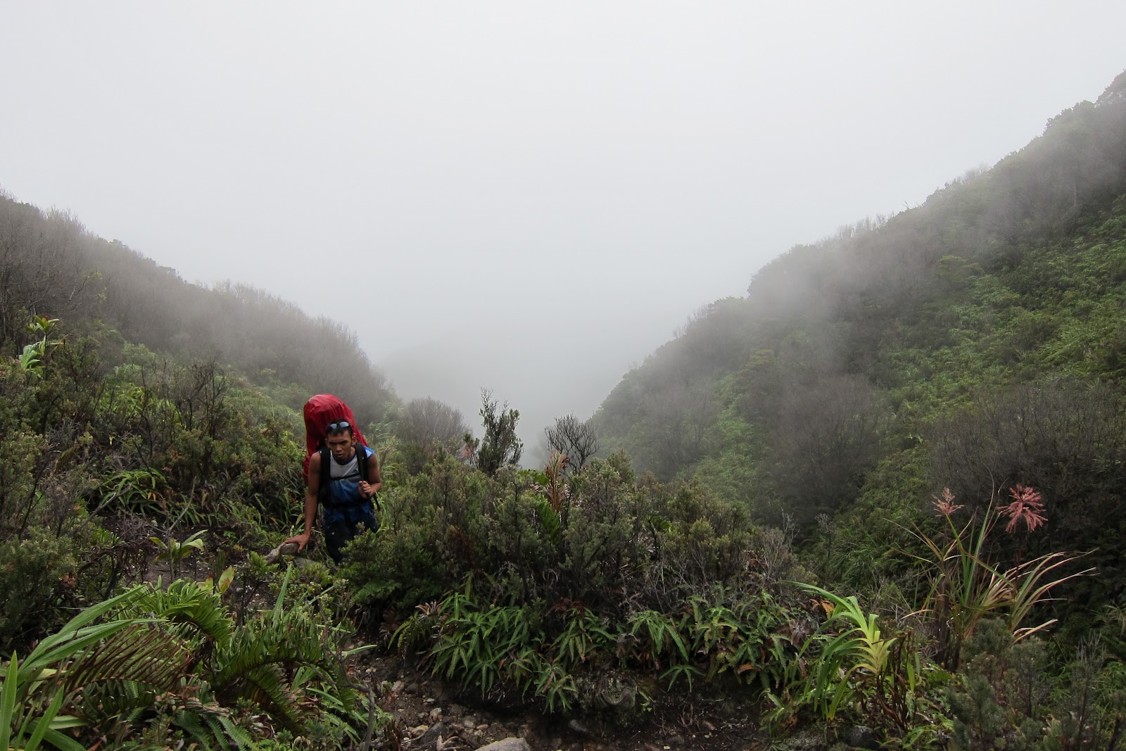
And then…uphill again. The trail was similar to the one the day before but more. There was thicker vegetation, more obstacles, even more muddy and swampy trail and more and bigger fallen trees. With fewer stops to catch our breaths, we got to Camp Godi-Godi fast. It took us less than 2 hours. It is named after an old man who used to go up and down the mountain, creating and clearing up trails and campsites. Our guide Cholo says that he is now about 70+ years old. A few years before, he used to climb the mountains during peak climbing season at holy week asking people…”Kilala nyo si Godi?”…but never introducing himself as that man. He would also sell his soda and rum. Now, he lives just a couple of hours before Baroreng in a cozy and lovely wooden home sitting in the middle of nowhere.
Below is Godi's beautiful home garden and a stash of empty alcohol bottles waiting to be brought down to the stores in exchange of new full ones!


Below is Godi's beautiful home garden and a stash of empty alcohol bottles waiting to be brought down to the stores in exchange of new full ones!
Godi-Godi is a much wider space but the water source is not as good as the one in Baroreng. There are also piles of garbage in several areas of the site, left behind by campers who have come and gone.


After a 30-minute rest, we started our 5-hour continuous ascent to the summit. An hour into the forest, I began to notice the trees slowly disappearing and shrubs appearing. By this time until we reach the summit, we would be completely exposed to the sun and the wind. My prayers for good weather were answered. It was a hot day with momentary comforts of swiftly passing fog and clouds.
The point just before the boulders was covered with wild berries, grass, shrubs, all with sharp and tough leaves that enable it to withstand the harsh shift in temperature. Some were even frozen to death. We did not see any monkeys but our guides said that they come to this area to feed on the beautiful and colorful wild berries. I tried one that looked like blueberry. It tasted somewhat like guava with small seeds inside.


The air became thinner as we soldiered on and everybody was breathing heavily.
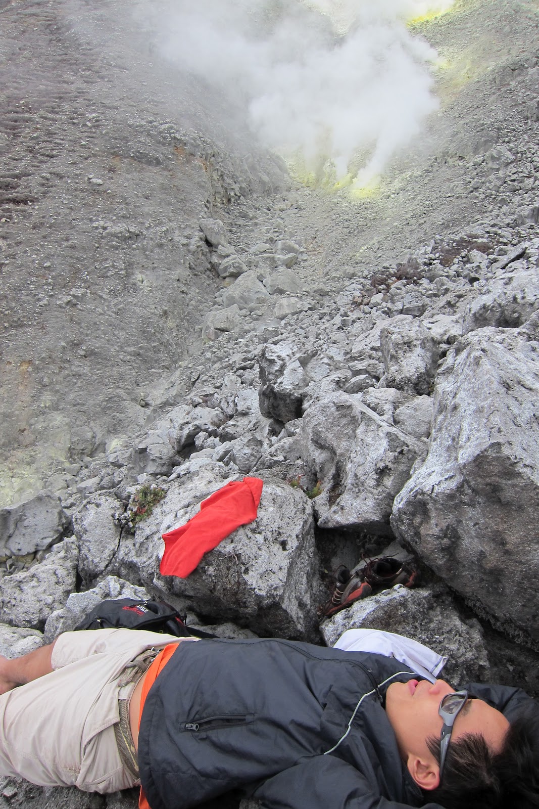
A few minutes and shrubs were gone and all that is left was the giant rocks and boulders. It was way above the cloud level and we were at the mercy of the scorching heat of the sun. At one point, my nose started bleeding so I quickly rehydrated myself. The sulphuric smoke that we passed in certain stages of the assault was so strong that it made us cough. From this viewpoint I could already see some parts of the boulders with steam coming out and beautifully colored with bright yellow. Everywhere I looked, the view was amazing!
At exactly 12:00 noon we had packed lunch of paksiw na baboy with banana blossom and rice at the boulders. After lunch and under direct sunlight, I even managed to doze off for 15 minutes.


After our much needed rest, we prepared to get moving again. When I looked up, I could already see summit! It looked far and I was sure that I was still in for a long climb.


We then rested for a bit at the place they call “white sand”…more like white pebbles to me. It was a charming little patch of land that looks a lot like someone’s garden with white pebbles, shrubs, wild berries, bonsai plants and some flowers.
We were barely 30 minutes to the summit. As I looked up, I got a bit worried…this might very well be a repeat of the Mt. Mayon climb to the crater with almost 90 degrees slopes!!!
Then…the crater! The walls of the crater are defined. It has a small lake at the middle. We took pictures for several minutes.


One final assault…one final 15-minute push and we were standing at the summit of the highest mountain in the Philippines!!! What a great achievement. This would be my last climb and there is no better way to end my days of mountain climbing that this! What a marvelous creation!


We set up camp a few kilometres down from the summit. It is a wide plane but is a very windy location because this is where the winds coming from different regions surrounding the mountain range meet. After cleaning up in freezing cold water, we went in the tent to put on more layers of clothes. I had about 4 layers but my feet and hands were still numb. To my despair, the night was a lot colder than the night before and it was very hard to take uninterrupted sleep. I remember waking up at 1am and then at 2:33am and then again at 4:00am wishing for daylight to come.
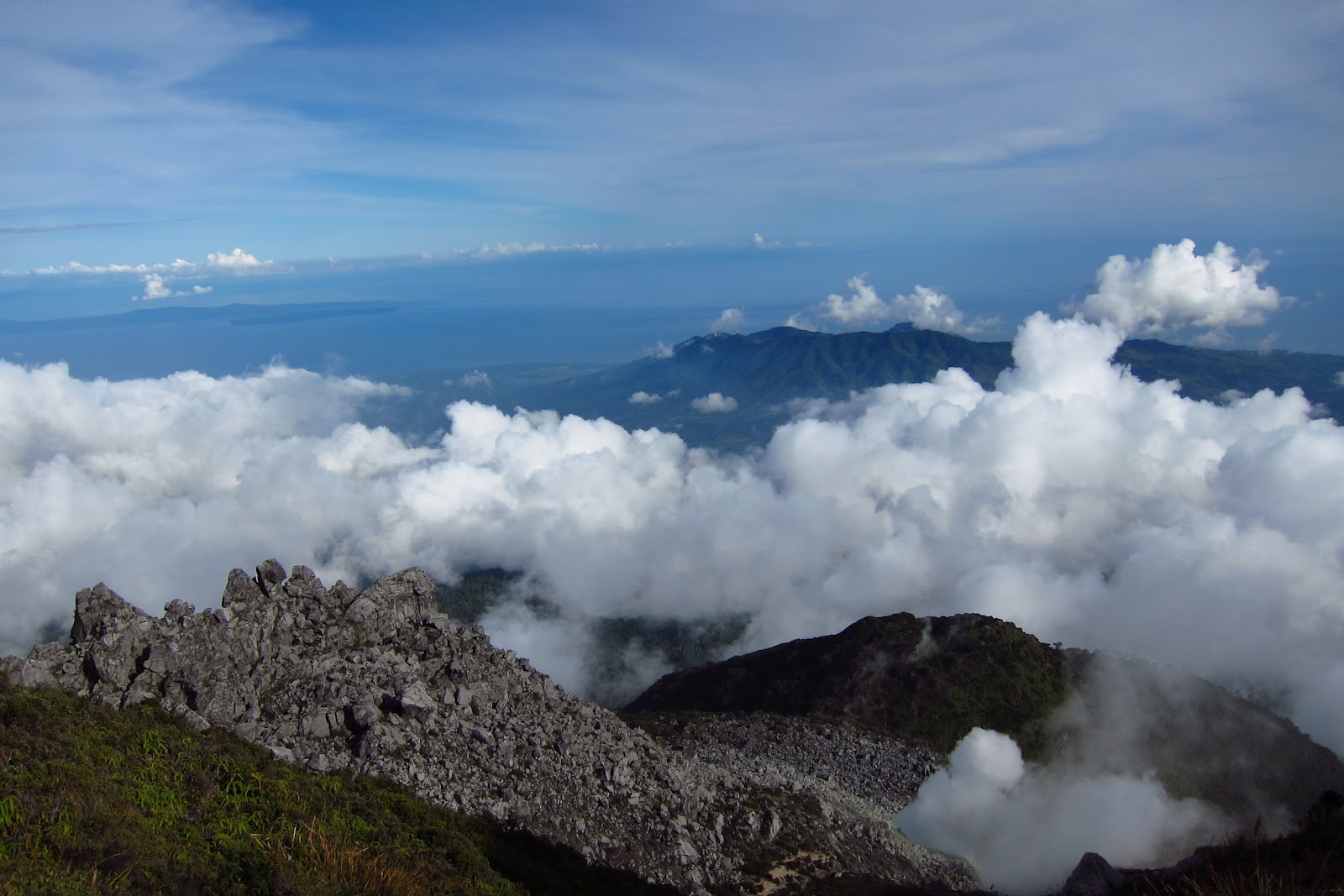
We woke up at sunrise and reluctantly went to one of the peaks. I’m glad we did because in spite of the bitter pinching cold, the view was (for lack of a better way to describe it) breathtakingly extraordinary!


Breakfast was rice, chicken tinola, a salad of cured beef and crunchy cucumber in vinegar, longganisa dipped in Pinakurat (a native cured coconut vinegar) and crispy dried salted fish.
After packing up and staying under the sunlight to keep us warm, we started our descent. The trail was everything like the day before in reverse. The trail to Agco, Kidapawan is quicker but more dangerous and a lot steeper. First was the 2-hour trek to Lake Venado where we walked past sharp bushes and grass. On this trail we met one local man and some local kids and handed them some trail food. They are hired by the local DENR and an NGO to plant seedlings to patches of land that were left barren by a forest fire years before.
Then, a thick jungle...a swampy terrain…and voila! Lake Venado!


This is another camp site that gets flooded up to 30 meters deep during rainy season and dries up when it is hot. This is where a huge party happens in the peak climbing season during holy week where mountaineers from all over rendezvous once a year.
It was a hot day and as I walked across the dried up lake, I could hear the land and the hard grass cracking.
After the open plane of Lake Venado, we entered the jungle again where we pushed our way to an even more steep and muddy trail. Some parts were almost 90 degrees sloping. Thankfully, locals have put ladders in these parts.


After a packed lunch of chicken adobo and rice and iced tea, passing through some more jungle and some landslide areas, we reached our final stretch…the river trek. I quickly rinsed my face and head with cold water. It was such a relief.
The water in Marble River flows very swiftly and one has to be extra careful crossing it. The rocks were covered in orange color and the water is crystal clear. The water is good for watering the fields and bathing but not good for drinking since the water has passed through a power plant before reaching our exit point.


We had to cross the river several times, cross wooden bridges for 5 times, stop to get water in the last water source, climb on a final hard ascent and then…a wide ROAD! CIVILIZATION!...the end of this adventure!
It was bitter sweet…sweet because I had longed for a warm and comfortable sleep and shower but very bitter because I was amidst so much peace and so much beauty that it was hard to leave it behind.
A Lot of Firsts…
I had a lot of firsts in this adventure. In a long time, the first time I wasn’t able to check my emails and text messages in four days. I didn’t mind this and I actually learned to appreciate the peace and quiet that it brought. The first time I did not need an ipod during trekking. I easily get bored and depend on my trusty ipod playlist to get me through the long walk. Since most of the trail was either damp treacherous, I had no chance to use it. Thinking about it after the climb, I was surprised that I did not even notice it anymore a few minutes into the trip. The flora and fauna, the view and the experience was just so amazingly great that the gadgets that I have gotten used to just seemed silly and unnecessary.
It was my first time to bathe and clean up in freezing cold water, my first time to sleep in harsh and numbing cold weather.
It was my first time to see that much garbage left by visitors. Our guide says that they organize a yearly cleanup of the mountain. But wouldn’t it be better if everyone took their trash back to the city so that it never has to sit in the mountain for a year? This is both a sad and surprising revelation for me. Whatever happened to the mountaineer ideal…TAKE NOTHING BUT PICTURES, LEAVE NOTHING BUT FOOTPRINTS, KILL NOTHING BUT TIME?!!! We are all just visitors of the great Mt. Apo. Let us all be thankful that it welcomed us with open arms and greeted us with all its majesty. Let us preserve it and take care of it. At the lunch stop on our final descent, I unconsciously thought aloud and said…”I wonder if these will all still be here for my kids to see?”.
It was my first time to trek in that many conditions. Foggy, muddy, swampy, burning heat, bitter cold, double foggy, double muddy, double swampy, double the burning heat, double the bitter cold and more!
It was my first time to be in the midst of such great company while climbing. I’ve climbed with friends but this is a different scenario since we met them only at the start of our climb and I would usually be aloof to people that I don’t know. These ones were different though. Because of the easy-going and fun nature of our guides Cholo, Paolo, Vince and Aix, I was instantly comfortable with them and we came out of the experience being friends. Our experience with them made our climb so much easier.
It was my first time to stand in awe of God’s creation and truly say..”This is breathtakingly beautiful”.
It was my first time to say out loud…”This is my last and final climb”.